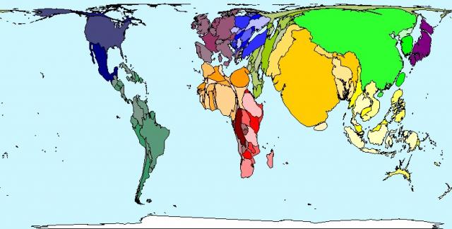
In Spring 2000 world population estimates reached 6 billion; that is 6 thousand million. The distribution of the earth’s population is shown in this map. India, China and Japan appear large on the map because they have large populations. Panama, Namibia and Guinea-Bissau have small populations so are barely visible on the map. Population is very weakly related to land area. However, Sudan, which is geographically the largest country in Africa, has a smaller population than Nigeria, Egypt, Ethiopia, Democratic Republic of Congo, South Africa or Tanzania.
The following table shows the population in million people of the highest populated 10 countries.
Rank | Territory | Value in millions |
1 | China | 1295 |
2 | India | 1050 |
3 | United States | 291 |
4 | Indonesia | 217 |
5 | Brazil | 176 |
6 | Pakistan | 150 |
7 | Russian Federation | 144 |
8 | Bangladesh | 144 |
9 | Japan | 128 |
10 | Nigeria | 121 |
http://www.worldmapper.org/posters/worldmapper_map2_ver5.pdf
