The Irrawaddy Delta (Ayeyarwady Delta in Burmese language) lies in the Irrawaddy Division, the lowest expanse of land in Burma (Myanmar) that fans out from the limit of tidal influence at Myan Aung to the Bay of Bengal and Andaman Sea, 290 km to the south at the mouth of the Ayeyarwady River.
The delta region is densely populated, and plays a dominant role in the cultivation of rice in rich alluvial soil as low as just 3 meters above sea level, although it also includes fishing communities in a vast area full of rivers and streams.
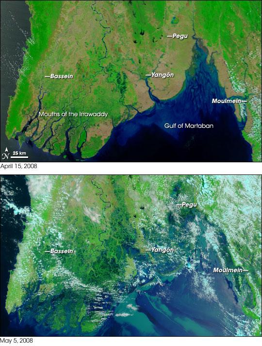
On 2 May 2008, the delta suffered a major disaster, devastated by Cyclone Nargis, which reportedly killed over at least 77,000 people with over 55,900 missing, and left about 2.5 million homeless. The photo shows the delta area before and after the impact of Cyclone Negris. The satellite photos from NASA's Terra satellite, showing part of Burma/(Myanmar) on April 15, 2008 (top) and May 5, 2008 (bottom), resulting in before-and-after comparisons of the impact from Cyclone Nargis.
The Irrawaddy Delta comprises the main arms of Pathein River, Pyapon River, Bogale River, and Toe River. The waters of these rivers are very turbid due to a heavy silt load they carry and the sea is very shallow with depths less than 5.5 m across the coastline and in the east for a distance of up to 28 km offshore. As a result of constant accretion into the sea, the delta is advancing at a rate of 5–6 km per 100 years, equivalent to about 1,000 hectares per year.
Water purity lies within the pH range of alkaline condition due to early natural resources and weak environmental control. Mangroves or Lamu and nipa palm or Dani are the major vegetation of the delta. Moreover, control of weeds is less active as local farmers make mats during the summer. Destruction of mangroves and deforestation in the coastal region due to the Cyclone Nargis put it more at risk in future.
The region is Myanmar's largest rice producer, so its infrastructure of road transportation has been greatly developed during the 1990s and 2000s. Two thirds of the total arable land is under rice cultivation with a yield of about 2,000-2,500 kg per hectare. Fishing is carried out from fixed fishing frames as well as from small boats. Prawn fishery and harvesting sea turtle eggs are also major commercial activities both of which are now threatened by the loss of mangrove forests as clearing of land proceeds for agriculture. Since communication throughout the delta is easiest by water, almost every household possesses a boat and major towns such as Bogale, Mawlamyinegyun and Myaungmya are served by steamer.
Meinmahla Kyun Reservation is a national heritage site as well as a natural habitat to many mangrove forests and diverse sea life. The Irrawaddy dolphin is not a true river dolphin native to the Delta region, but it was named after the river, and these sea dolphins are known to enter the rivers of South East Asia.
http://en.wikipedia.org/wiki/Irrawaddy_Delta
http://www.agrimarketing.com/show_story.php?id=49230
http://upload.wikimedia.org/wikipedia/commons/0/0d/Cyclone_Nargis_flooding_before-and-after.jpg
