Source of the photo
http://www.deldunantul.com/old/index.php?id=2740
Author of the description
Gruiz Katalin
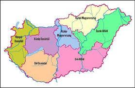
Hungary is devided into sven adminstrative regions from 1999. The regional structure has been established tin order to join the European Unions support system (NUTS: Nomenclature of Units for Territorial Statistics). Information on the regions of Hungary are shown in the table.
| Name | Area (km²) | Population | Density (capita/km²) | Counties | Towns |
|---|---|---|---|---|---|
| North-Hungary | 13 428 | 1 236 690 | 92 | Borsod-Abaúj-Zemplén, Heves, Nógrád | Miskolc, Eger, Salgótarján |
| Northern Great Plain | 17 749 | 1 514 020 | 85 | Hajdú-Bihar, Jász-Nagykun-Szolnok, Szabolcs-Szatmár-Bereg | Debrecen, Szolnok, Nyíregyháza |
| Southern Great Plain | 18 339 | 1 334 506 | 73 | Bács-Kiskun, Békés, Csongrád | Kecskemét, Békéscsaba, Szeged, Hódmezővásárhely |
| Central Hungary | 6 919 | 2 897 317 | 419 | Pest, Budapest főváros | Érd |
| Central Transdanubia | 11 237 | 1 104 841 | 98 | Komárom-Esztergom, Fejér, Veszprém | Tatabánya, Székesfehérvár, Dunaújváros, Veszprém |
| Western Transdanubian | 11 209 | 997 939 | 89 | Győr-Moson-Sopron, Vas, Zala | Győr, Sopron, Szombathely, Zalaegerszeg, Nagykanizsa |
| Dél-Dunántúl | 14 169 | 960 088 | 68 | Baranya, Somogy, Tolna | Pécs, Kaposvár, Szekszárd |
Source of description
http://hu.wikipedia.org/wiki/Magyarorsz%C3%A1g_r%C3%A9gi%C3%B3i
